Using Navigation charts and electronics
Navigation charts and Electronics
For Navigation aids, we will have a varity of aids, starting with my 2 main Lowrance GPS/chartplotters/depthsounder which have a 6″ screen. These compbine the chartplotter and depth sounder in one unit and as I have 2 units, I use one as the chartplotter and the other as the chartplotter.
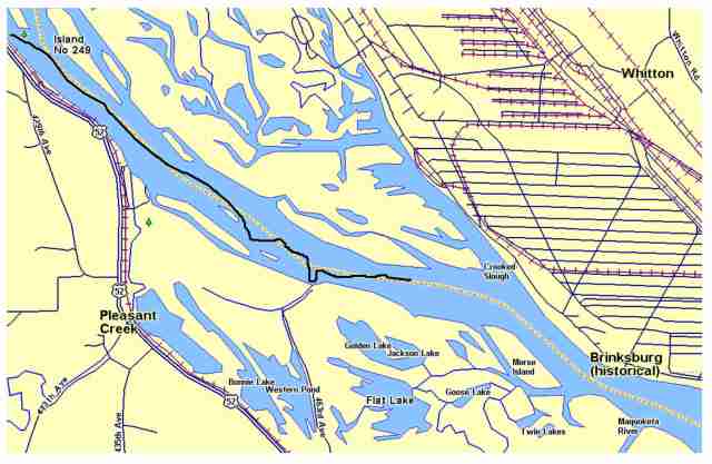
The chartplotter screen shows the river, islands, marinas, waypoints and other details on the screen. and shows a track of the area traveled and a line to a plotted waypoint, as well as distance and bearing to that selected waypoint. However, this will be somewhat limited on the river as one must still follow the river channel. A diagram of the screen map is shown below.
| chart plotter screen |
This unit provides the most accuracy as far as the gps position and the map features, but as the unit is fairly old, the map features such as islands may have changed somewhat due the the dynamic nature of the river.
We will also have the Corps of Engineers printed navigation charts which show the river similiar to the screen of the above gps screens, but also show the river mile data, the naviagation aids such as naviagation lights, daymarkers, and channel marking buoys, as well as boat ramps, marinas, and most important it shows the various wingdam and closing dam locations, as well as gives the lock and dam information useful in locking thru.
As we will also have computers on board, I have downloaded USDA georeference aerial photos for each county along the way and did additional georeferenceing for each one. These, with a GPS mouse type reciever connected to the computer, and the appropiate software can provide us with moving aerial photos that will provide us with a real time location on a aerial photo, showing the recent track traveled, current bearing, speed, etc. As these photos are current photos (2012), they will show more current detail of the river as well as land types, ie trees, cleared land, sand bars and beaches, docks, marings, and other features, They will be very useful in looking down the river to find suitable overnight areas behind islands or up backwater sloughs and channels. A example video screen photo is shown below.
The above video show the computer screen showing the aerial photo, with the little yellow boat as our current location on the river, with the blue line as the rack recently traveled and the straight dotted line extending in front of boat showing the current direction of travel. This will be like driving down the aerial photo.
Both the computer aerial photos and the gps unit will have waypoints plotted of various marinas, bridges, adjacent river and creek mouths, and other features programmed in from google earh maps. And lastly, we will take our TomTom gps device along, which although, primarily for use on road and streets, it can still give us much information and locations of various business such as gas stations, resturants, hotels, hospitals, and many other locations that may be needed as well as these phone numbers. Lat-Long positions of our various overnite spots and other interesting locations and features will be posted on the daily blog pages as we go during the trip as well as photo, videos, and other highlights.
back to top :: About Stan and Milt


Jan 13, 2013 @ 14:31:38
Go easy with your daily logs – meaning don’t let the activity consume or take you from the your personal reason for being there – its a fulfilling (and interesting trip). A short/rough outline (high-points) for the day works – then come back to your pictures and notes once home and elaborate. It will ‘all come back to you’ – the memories will remain fresh for years.
Looking forward to your trek…..
Feb 06, 2013 @ 01:39:59
Portc Fracis